In 2006, ESTEIO pioneered the highest technology in digital airborne sensors in the Brazilian market. At the time, we invested in the Leica ADS40 trilinear sensor.
In 2020, amidst a period of great uncertainties brought by the new Coronavirus pandemic, ESTEIO has taken yet another leap of faith into its field and modernized its set of instruments with a huge new investment in the large-format Airborne Digital Sensor LEICA ADS100 – which represents the state-of-the-art technology in digital airborne imaging.
We have come up with the following questions and answers to enlighten our clients, partners and other interested parties about this wonderful technology.
The world is going through a pandemic and ESTEIO has decided to invest in a new airborne sensor. What is the reason behind this decision?
Technological development is happening faster and aerial survey companies must keep up-to-date in order to stand alive and competitive. Throughout over 50 years in the market, ESTEIO has made huge investments, none of which had one sole purpose. They always concern innovation, strategy, necessity, and opportunity. The image collection phase, despite being usually the shortest step in a mapping service, is the phase that poses the greatest impact on the costs and deadline of a contract, precisely due to its absolute dependence on the weather, time restrictions, and sharing of the airspace. Hence, it is crucial to have at hand a reliable and high-performance aircraft and sensor to make the most of such little available time.
Why has ESTEIO invested heavily in a large-format digital airborne sensor when drones have become so popular?
Drones are active instruments in the imaging market, but most of them do not produce images aiming at precision mapping, and when they do, the images taken are of small areas. We have invested in a high-technology and high-productivity sensor, which little resembles the small cameras installed in most of the drones available. The Leica ADS100 sensor allows for obtaining images with individual and distinct spectral bands, multiple stereoscopic views, and other unique resources that generate images with an appropriate geometry for technical services that demand high quality and information integrity. To provide some perspective, the ADS100 sensor and its peripherals weigh about 120 kilograms, whereas the small cameras on drones usually weigh less than 1 kilogram, that is, they are over 100 times smaller. When it comes to cost, they are about 1,000 times cheaper.
Technologically speaking, what is the difference between the sensor on a drone and the LEICA ADS100, ESTEIO’s new sensor?
It is almost like comparing a bicycle to a Mercedes-Benz or Bentley – they share little or absolutely nothing in common. Both “sensors” may take beautiful aerial images, although with huge differences in geometric and radiometric quality, and also in efficiency. In the past few years many countries have had their territory mapped, usually with the ADS100 sensor due to its high productivity, quality and reliability. It would not have been possible to accomplish this kind of survey with the small cameras installed on drones. Precision mapping is not, yet, a suitable fitting application for drones. ESTEIO also performs services using drones, which are employed in small surveys, and in low-cost imaging services that require few technical resources.
Most Brazilian aerial survey companies have medium-format sensors. Why has ESTEIO decided to invest in a large-format sensor?
ESTEIO is primarily concerned with catering to the demands of its clients, who are the reason why the company exists. ESTEIO already owns small sensors for use with drones, and medium-format sensors that function along with the LASER sensors. Our last large-format sensor, the ADS40-SH52, was upgraded in 2009, and was currently in need to be modernized according to the demands of the cartography market. With its latest acquisition, ESTEIO aims to keep its leadership and remain up-to-date in mapping technology.
What are the technological differences between the ADS100 sensor and the ADS40?
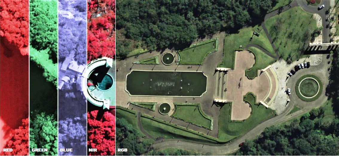
The ADS40-SH52 sensor is the second-generation LEICA linear digital sensor, whereas the ADS100 is a fifth-generation sensor. All technology advancements of the past few years have been included in the latest ADS100 sensor. There has been a significant weight reduction from 230 to 120 kilograms, and also a reduction in power consumption. Such improvements reflect in longer range, higher memory capacity and recording speed, making it possible to acquire data faster or in low light, increasing productivity in up to 70%. The higher resolution allows for obtaining images with GSD of up to 3 cm, and the broader field of view allows for larger coverage. Moreover, the novel TDI (Time Delay Integration) on a linear sensor avoids image smearing. All of these features result in a more productive sensor with lower operational cost, in addition to the numerous other differential elements as compared to the vast majority of sensors available in the Brazilian market: gyro-stabilized mount, high-performance inertial system, unique telecentric lens with interference filters, Red, Green, Blue and Near-Infrared spectral bands individualized in all three views, 20,000-pixel nadir images across track, etc. The ADS100 has two Sensor Head versions: the SH100 and the SH120, the main difference between both cones, or sensor heads, being the focal distance of 62.5 mm and 120 mm respectively. For ESTEIO, the SH100 is more suitable.
When investing in a new sensor, isn’t it necessary to also invest in software?
Yes and no! For ESTEIO, one of the advantages in purchasing the Leica ADS100 sensor is that the process flow is the same as for the ADS40. The investment made in software was only for updating the system to more recent and efficient versions. Additionally, when investing in a step which is the beginning of the mapping process, we are also investing in all of the production chain, because all processes go through small changes, and, therefore, all technicians must undergo training courses. Hence, the investment in hardware was also in software and “peopleware”.
Why has ESTEIO invested in the ADS100 and not in an oblique sensor?
Oblique imaging, along with 3D modeling, shows great market potential; however, it is still too expensive for most of our clients and Brazilian local governments, few being duly prepared to explore and deal with the great amount of information produced. In 2016, ESTEIO performed the first oblique mappings in the country, of Barra Olympic Park, in Rio de Janeiro, and of Curitiba, in a pilot project for getting to know and spread the technology; nowadays ESTEIO masters this technology. When purchasing the ADS100, we are also purchasing almost all peripherals and software for an oblique sensor, so that, in case there is demand, we must simply acquire the cone, and, since we have experience in the field, put it into operation. Since the head of the Leica CityMapper hybrid sensor also contains a LASER sensor, we have chosen to invest in an oblique sensor in the future, possibly along with the upgrade of our LASER sensors.
Why invest in a linear sensor and not in a full-frame sensor as most of the Brazilian companies?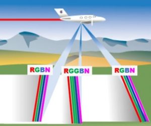
Firstly, because our previous large-format sensor was, indeed, of the linear type, the ADS40-SH52, also called a scanning sensor or pushbroom, and we have always been satisfied with its quality and reliability. Secondly, and more important, because this technology has already proven to be extremely efficient, and it allows for capturing the best images from a geometric and radiometric point of view. It is the only multispectral imaging technology available that does not use “pan-sharpening”, that is, images are captured directly in their native resolution in the R, G, B and NIR spectral bands, and, when combining them, the final image does not display “ghosts” when capturing moving vehicles, or color duplication due to pan-sharpening. There are thirteen linear sensors on a single focal plane. The system, in addition to being highly efficient, also gathers fewer images by area, displaying the slightest perspective distortions and high geometric stiffness as compared to other technologies. Our medium-format sensors are of the frame type; therefore, we also offer services using this technology, which is what most of our competitors offer.
How does ESTEIO choose from the frame and the pushbroom sensor technologies when offering a service to its clients?
Even though it is possible, a frame sensor, especially a medium-format one, may not always cater to the client’s needs and specifications, especially if the client requires multispectral imaging in the distinct R, G, B and NIR bands, images without smearing, use of a stabilizing mount, and other requirements. However, if by any chance both sensors can fulfill the demand, we will recommend the cheaper alternative, that is, we always analyze the cost of the service with either technology.
But if the linear sensor offers all these advantages, and, more importantly, has a higher acquisition cost, wouldn’t the cost of the services be higher as well?
Not necessarily. Depending on the specification and on aspects such as the size of the area, location, weather conditions around the area, type of product required, etc., the cost of the service may be lower than one performed with a frame sensor of large or medium format. As the ADS100 is much more efficient, it will require a shorter time in the air, and, consequently, its impact on cost and time to conclude the service will be lower. Our clients, at least those who are familiar with both technologies, generally hope that the scanning sensor be used in their contracts.
We know that the traditional concept of stereoscopy is different in the linear sensor. Does that pose a limitation to this technology?
Not at all! Both forms of data collection, with a frame or pushbroom sensor, have been on the market for a long time. Satellite images have been collected with linear sensors ever since the 70’s. Along a flight strip obtained with a trilinear sensor there are three views, and three distinct stereoscopic pairs can be used, either made up of the forward and backward views, nadir and backward views, or nadir and forward views. This considerably improves the working conditions. Since each strip makes up one stereoscopic model, the overall number of models and images of a flight with a pushbroom sensor is much lower than that using a frame sensor. Moreover, the scenes or images of continuous strips can be prepared, clipped, and exported in the form of frames that can be used in numerous conventional stereoscopic view systems.
Can you give an example of this reduction in the amount of images?
Yes. Recently ESTEIO aerophotogrammetrically mapped the city of Curitiba with the Leica ADS40 sensor with an 8-cm pixel (GSD) and 60% lateral superposition. It took only 102 image strips and models in order to cover an area of flight of 550 km². If, hypothetically, we had used a large-format frame sensor, with equivalent longitudinal superposition of 80%, we would have gathered about 9,000 images; if we had used a medium-format sensor, we would have gathered around 22,000 images; and, had the use of drones been technically and economically viable, there would have been about 65,000 images. These numbers were estimated based on the sensors owned by our partner companies at the time. On top of that, if we had already purchased the new ADS100 sensor, there would have been only 61 scenes and models.
Why wouldn’t it be technically viable to map Curitiba using a drone?
There are numerous reasons. The Government of Curitiba needed a multispectral survey, that is, distinct R, G, B and NIR bands, which makes it technically impossible to use drones, and, if their use were possible, it would take a large number of flights, dramatically increasing collection time, processing for delivering a radiometrically uniform product, and the number of images and control points. One of the products to be delivered is the restitution update with PEC A (Brazilian Cartographic Precision Standard A) precision, and, if we could afford the exhausting task of working with over 65,000 stereoscopic pairs, this would render the service impossible either due to the longer time required or to the financial impact. The survey with the ADS sensor required 9 hours of photo flight; if a drone had been an option and it were possible to collect all bands with a single survey, around 250 hours of flight would have been needed, that is, almost 28 times longer under favorable atmospheric conditions and free airspace. Besides, since a drone flies at low height, small relief variations would demand more flight levels, which would further increase the number of images.
The linear sensor has got three views: forward, nadir, and backward. Are the forward and backward views oblique?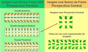
Yes! With 19- and 26-degree angles with respect to the vertical. The best oblique sensors available on the market nowadays, depending on the manufacturer, have views within a 15- to 45-degree range, and simultaneously collect four oblique RGB views and one nadir. If we make two perpendicular flights using the ADS100, we will map the equivalent of one oblique flight with four views within this range, and also two nadir surveys in RGBN, without mentioning the advantage of having two distinct tilts in each range, which is a great differential in the “obstruction” of objects in a sensor with oblique view.
Is the nadir view of the ADS100 sensor the most important image?
Not exactly the most important, but, yes, the most used one, because it is the kind of image that displays the slightest perspective distortions. The nadir scene is the first of the three options to be employed in orthorectification, since its resulting product is a semi-true orthophoto. The image distortions due to the lens perspective only exist across track, whereas in the image obtained by a frame sensor they also exist along track. If we increase the flight’s lateral superposition with a linear sensor, an orthophoto with “true” orthophoto features may be generated at the cost of a conventional orthophoto.
Will mapping with drones replace mapping with planes?
Drones or planes, or even satellites, are merely the vehicles that transport the sensors, which are the real subjects that determine the quality of the survey. Today, it is financially impossible to operate a 120-kilogram sensor with a drone. Unmanned vehicles with high load capacity are still too expensive when compared to manned aerial vehicles, which are also safer. The sensors that feature all state-of-the-art technologies are heavy and depend on a lot of power to be operated with drones. In the future, if these sensors are miniaturized, or when larger drones are common in the market and with fewer operational restrictions, such a replacement may be feasible. And we look forward to this moment!
What are the state-of-the-art large-format sensors currently on the market?
There are presently only two large-format sensor manufactures in the market: the Swiss Leica Geosystems, by the Hexagon Group, and the Austrian Vexcel. Nowadays there are three state-of-the-art sensors, a linear one and two frame sensors: Leica ADS100, Leica DMC-III and Vexcel UltraCam Eagle Mark 3, and each of these sensors has more than one version or model.
Valther Xavier Aguiar is a cartographic engineer, Chief Technical Officer of ESTEIO Engenharia e Aerolevantamentos S.A. and
President of ANEA – Associação Nacional de Empresas de Aerolevantamento.
valther@esteio.com.br, www.esteio.com.br, October/20
All rights reserved. Copyright 2020 ©, ESTEIO Engenharia e Aerolevantamentos S.A.