
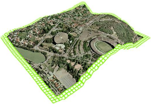
Digital Orthophoto Map is a cartographic product that combines the rich detail of a photographic image with the geometric quality of a line map, and can be used just like a map.
The term orthophoto refers to the differential rectification of photographic images based on a digital terrain model (DTM). The process aims to correct lens distortion effects and aerial camera tilt, image scale variations and object displacements due to relief.
It is produced using a precision computerized imaging system.
Analog to Digital
When the flight is carried out with analog photogrammetric cameras, the images that will generate the orthophoto are scanned. Scanning is the means by which the analog image, the diapositive or film, is converted into a digital image (a binary file associated with an ASCII interior orientation file that reproduces the scanned image digitally).
The analog image is captured by the scanner's CCD sensor and represented by a regular matrix of pixels (Picture Elements), where each pixel is associated with a DN (digital number) representing a shade of gray or RGB tone from the original scene.
The formats of these binary files can be specified as TIFF, JPEG, or other image formats requested by clients.
Digital ADS40 Images
Images can also be acquired by the ADS40 digital camera, in which case scanning is not necessary. This camera has high geometric and radiometric resolution. Images are collected in strips, improving the joints between orthophotos.
Image Distortions
The photographic image of the terrain appears distorted due to several factors inherent to the photographic process, such as:
Due to the scale inhomogeneity that these distortions cause, we cannot make coordinate, distance and area measurements directly on a photograph.
Image Rectification
The Orthophoto is obtained by correcting the image distortion factors, that is, the central projection is transformed into an orthogonal projection, the earth's curvature and terrain topography are corrected to make the scale homogeneous, etc. In other words, the image is "flattened, stretched and compressed" until the terrain features appear in their correct position and at a homogeneous scale.
The digital image is transformed into an orthophoto through Differential Rectification.
The principle of Differential Rectification consists of transferring the DNs from the aerial photograph to a fine, regular grid that represents the orthogonal projection of the terrain (DTM).
Their positions in the digital image are found according to the photogrammetric projection equations, with the interior and exterior orientation parameters (Aerotriangulation) being fundamental at this stage.
The relevant DN value is found through a convenient interpolation with adjacent pixels (called resampling) and related to the orthophoto pixel.
Final Product
The final resolution of the orthophoto obtained is determined based on the equipment on which it will subsequently be manipulated and the plotter to be used to generate the conventional final product.
For conventional use, where images are manipulated on microcomputers and plotted using inkjet printers, orthophotos are generated with a resolution of 254 dpi.
Capabilities
ESTEIO has extensive experience in the production of analog orthophotos and, starting in 1994, became the first Brazilian company to produce digital orthophotos. For Digital Image Processing, to produce orthophotos, ESTEIO uses:
-
Leica Geosystems Digital Photogrammetric Workstations;
-
Vexcel 5000 UltraScan scanner with resolution starting at 5 microns for diapositives, films and photos;
-
HP Designjet Z6100 Plotters;
-
Leica Geosystems ADS40 Digital Camera;
-
Leica Geosystems ALS50 LASER Sensor;
-
Leica Geosystems RMK TOP Camera;
-
Specific software for file manipulation.
Related Articles
- Mapping of Operational Areas of Vale in the Iron Quadrangle/MG