
ESTEIO's pioneering spirit across the most diverse activities related to Mapping, Photogrammetry and Rural Cadastre, together with the constant improvement of its production processes, allowed the company to establish itself in the Engineering market and gradually increase its participation in the history of Brazilian Cartography.
From its rise to category "A" (EMFA) among aerial survey companies in Brazil to its most recent investments in Digital Mapping, ESTEIO has always stayed very close to major technological advances over these more than 56 years of existence.
Visit the links related to the years in which significant events occurred for the evolution of procedures and the adoption of advanced technology, and confirm ESTEIO's firm decision to always invest in the best to serve its clients.
Year 2026 – Leica CountryMapper Large-Format Hybrid Sensor
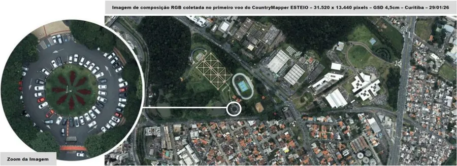
In 2026, ESTEIO acquired the Leica CountryMapper large-format hybrid sensor, manufactured by Hexagon Leica Geosystems (Switzerland), integrating a 423-megapixel multispectral aerial camera and a Hyperion3 LASER sensor at 2 MHz, expanding its capacity to simultaneously collect ultra-high-resolution images and high-density, high-precision point clouds for cartographic, urban and rural applications.
Year 2024 – AGITE Platform – ESTEIO Territorial Management and Intelligence Environment
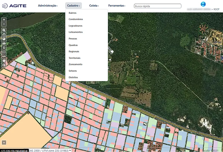
In 2024, ESTEIO developed the AGITE platform – ESTEIO Territorial Management and Intelligence Environment – with the purpose of integrating a geographic information system (GIS) with an administrative cartographic resource system, establishing a repository database of cartographic, thematic and territorial information for an urban space based on web visualization and administration.
With this system, users can publish and manage various activities involving the cartographic, cadastral and territorial management of a municipality, making such information available on a restricted or public basis as they see fit.
Spatial and thematic information is presented and managed in a traceable, understandable and easy-to-use way, which in turn improves monitoring and reporting and increases the effectiveness and accountability of urban space management.
Year 2023 – G2SMM Terrestrial Mobile Mapping
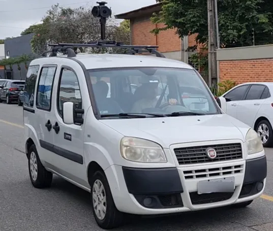
In 2023, ESTEIO acquired a G2SMM Terrestrial Mobile Mapping system from G2 Airborne Systems (G2AS). It is a technological solution for collecting 360° images on the move in urban or rural environments.
It uses a Ladybug 6 360° camera with five 12 Mpx lenses from Teledyne Inc, paired with a NovAtel OEM7700 + STIM300 GNSS/IMU system for georeferencing the captured images.
The equipment collects images with positional quality through a portable platform mounted on the roof of a vehicle. Post-processing derives a navigable immersive image, projected onto a virtual viewing dome.
Year 2022 – Leica CityMapper H2 Hybrid Sensor
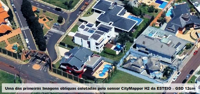
In 2022, ESTEIO acquired the Leica CityMapper H2 sensor, manufactured by Hexagon Leica Geosystems (Switzerland), with the following configuration: Hyperion2+ multi-pulse LASER at 2,000 kHz with recording of up to 15 returns; nadir camera with an 80 mm focal length in the RGB and NIR bands; four oblique cameras with a 150 mm focal length in the RGB band with 45-degree inclined views.
With this equipment, a single pass produces two nadir images, one RGB and one infrared, four RGB oblique images and a high-density LASER scan (2 MHz).
The image sensors have lenses developed specifically for photogrammetry and incorporate mechanical Forward Motion Compensation devices, which allow the acquisition of very high-quality images even in low-light conditions.
Year 2020 – Hexagon Leica ADS100 Digital Aerial Sensor
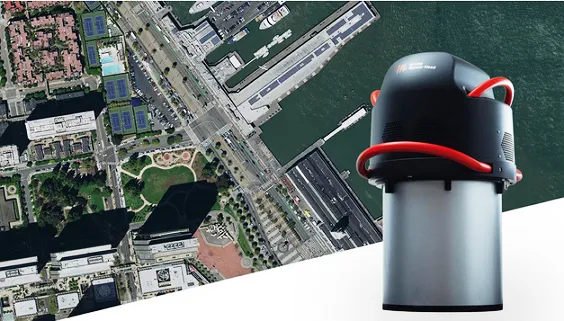
In 2020, during a period of great uncertainty caused by the COVID pandemic, ESTEIO once again demonstrated its confidence in its field of operation and modernized its equipment fleet with a major new investment, this time in the large-format LEICA ADS100 Digital Aerial Sensor, manufactured by Hexagon Leica Geosystems (Switzerland), which represents the state of the art in digital aerial imaging technology.
The camera has 13 linear sensors for continuous imaging with 20,000 cross-track pixels for the R(ed), G(reen) and B(lue) bands and the non-visible Near Infrared (NIR) band.
It has a swappable 3-terabyte memory capacity during flight and the ability to obtain images with up to 3 cm GSD (ground sample distance).
Year 2018 – R2Sonic Multibeam Echosounder
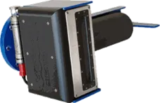
In 2018, ESTEIO acquired an R2Sonic model 2022 multibeam echosounder from R2Sonic Inc (USA).
This equipment is a compact, wide-band multibeam sonar suited to a variety of bathymetric surveys and required for surveys with detailed insonification of river, lake, estuarine or marine beds in special order, 1a and 1b (per IHO S-44) surveys of navigation channels for locating obstacles and objects.
Year 2016 – Multispectral Camera
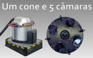
In 2016, ESTEIO used the HxGN Leica RCD30 Penta sensor from Hexagon Leica Geosystems to carry out aerial coverage of the Olympic Village park in Rio de Janeiro, host city of the Olympics in Brazil.
The flight covered an area of just over 16 km², totaling 850 vertical photos and 3,400 oblique photos, with a ground sample distance (GSD) of 5 cm and 2.3–3.5 cm respectively.
The multibeam echosounder became a valuable tool for determining depth whenever complete insonification of the seabed is required.
Year 2015 – Versatile Time Domain Electro Magnetic

As part of the company's interest in diversifying its market of operation, in 2015 ESTEIO signed an Unincorporated Joint Venture Agreement with GEOTECH Aerolevantamento S.A. with the purpose of joining forces to carry out airborne geophysical survey services.
Airborne geophysics is currently fundamental for mineral exploration, as it allows the identification of zones potentially holding concentrations of economically valuable minerals existing below the surface.
ESTEIO used the geophysical equipment from Geotech Ltd. called Versatile Time-Domain Electromagnetic (VTEM). The VTEM Plus (Versatile Time Domain Electro Magnetic) system is the most innovative and successful airborne electromagnetic system of the last 30 years.
Year 2014 – Mobile Mapping Systems (MMS)

In 2014, ESTEIO added Mobile Terrestrial LASER (MLS – Mobile LASER Scanning) or Mobile Mapping Systems (MMS) technology to its portfolio.
These Mobile Mapping Systems (MMS) allow the collection of 3D information for thousands of points along a road, in addition to images and/or video, while traveling at normal road speeds. The LASER performs a 360° scan of the road corridor with a range of up to 150 m, measuring 1 million points per second. The cameras capture 360° images around the vehicle at 2 Mpx resolution with 8 frames per second. Horizontal and vertical quality is centimetric when control points are used.
ESTEIO mapped Avenida das Torres (Av. Comendador Franco, which connects Curitiba Airport to the city), carrying out four types of surveys over a 16 km stretch – Mobile LASER, Static LASER, Aerial LASER and Orthophotos, in an unprecedented integration in Brazil that generated technical data of great value for the revitalization projects of this avenue.
Year 2013 – Leica ScanStation C10
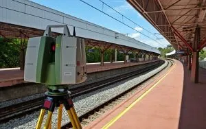
In 2013, ESTEIO employed Terrestrial LASER technology to survey subway stations in Belo Horizonte in order to obtain as-built data.
For this activity, the Leica ScanStation C10 was used, with a range of up to 300 m, a 360° x 270° field of view, a frequency of 50K points/second, and versatility for scanning both indoor and outdoor areas.
The point clouds and as-builts were processed with Leica Geosystems' Cyclone software.
Year 2012 – UAV Platform (Unmanned Aerial Vehicle)
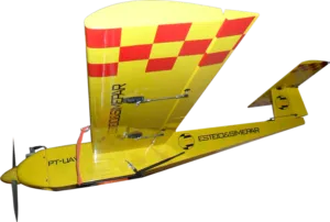
In 2012, ESTEIO and the SIMEPAR Technological Institute signed a Technical Cooperation Agreement envisioning joint action between the companies in the mapping and monitoring market using UAV (Unmanned Aerial Vehicle) platforms, internationally known as UAS (Unmanned Aerial Systems).
Today, UAVs and low-altitude photogrammetry represent a set of image collection and processing techniques that open up new opportunities for users of aerial imagery, enabling faster, more direct acquisition in specific, smaller areas where a traditional aerial survey is not the most appropriate solution.
The combination and integration of ESTEIO's skills and experience in Aerial Surveys under the SAE (Specialized Aerial Services) modality, Airborne Sensors, Photogrammetry, and the SIMEPAR institute's expertise in UAV systems for Environmental Monitoring, result in a highly significant and important competitive advantage in exploring this expanding cartographic segment in Brazil and worldwide.
Year 2011 – LEICA RCD-30
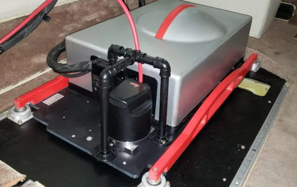
In 2011, ESTEIO acquired another aerial photogrammetric sensor, the LEICA RCD-30 medium-format camera from Leica Geosystems Ag, with frame imaging technology, which operates alongside LEICA LIDAR equipment, enabling simultaneous LASER and photogrammetric surveying.
Year 2010 – Aerial Camera (RCD-105)
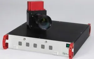
In 2010, ESTEIO introduced the RCD-105 aerial camera, produced by Leica Geosystems, to the Brazilian market.
The choice of this medium-format aerial camera was due to the operational advantages and product diversity it offered clients.
This camera operated with a 39-megapixel CCD (7,162 x 5,416 pixels) capable of obtaining RGB or infrared images using three lenses with 35, 60 or 100 mm focal lengths.
The year 2010 also marked the beginning of ESTEIO's activities in surveys using Terrestrial LASER.
Initially, these were restricted to static surveys, already widely used in the market and applied in the most diverse areas.
Year 2009 – Digital Echosounder
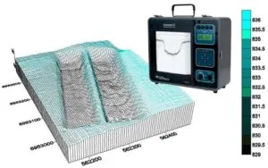
In 2009, ESTEIO acquired its second digital echosounder (single beam), the HYDROTRAC model from ODOM. The equipment operates at a frequency of 200 kHz, enabling depths of up to 100 meters to be reached, with an accuracy of 1 cm + 0.1% of depth. The equipment also allows for the substitution of transducers, this one at 33 kHz, reaching depths of up to 600 meters. Also in 2009, ESTEIO acquired the IDS GPR subsurface radar, Model – RIS MF Hi-Mod, a state-of-the-art product developed mainly for mapping buried utilities (interferences). Aimed at surveys in urban and rural areas, the equipment allows operation with two antennas at frequencies of 200 and 600 MHz, to simultaneously acquire data on subsurface elements with greater depth range. In addition, ESTEIO upgraded its ADS40 digital sensor. The sensor remained named ADS40, with the main change being its head, which was upgraded from the SH40 to the SH52 model. The main advantages of this upgrade were the change from Tricoide to Tetracoide, allowing for the acquisition of color or infrared stereoscopic models, improved image quality, and improved flight execution intervals.
Year 2008 – LEICA ALS-50 MPiA
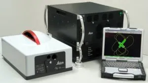
In 2008, another LIDAR device was acquired, the LEICA ALS-50 MPiA, capable of emitting and receiving multiple LASER pulses within the same time period.
This ALS50 MPiA equipment, from Leica Geosystems Ag, Switzerland, had the operational capacity to obtain three-dimensional terrain coordinates at up to 166,000 points per second.
Year 2007 – SAU – User Service Program
In 2007, ESTEIO participated in the execution of the Pilot Project to model a User Service Program (SAU) on the federal highway network, supporting the management of operational safety and communication and coordination systems for rescue operations on highways.
Year 2006 – Airborne Digital Sensor
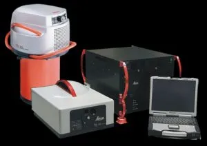
In 2006, the company made one of the largest investments in mapping technology in the country, acquiring the LIDAR LEICA ALS-50 equipment and the LEICA ADS-40 digital aerial photogrammetric sensor from Leica Geosystems Ag.
This allowed it to offer clients better mapping options, whether through the high point density of the LIDAR ALS-50 (150 kHz) or the extremely high imaging quality of the ADS-40 sensor, which enables the acquisition of stratified images in the RGB, PAN and Near-Infrared bands.
Year 2005 – SBP (Sub-Bottom Profiling)
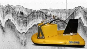
In 2005, ESTEIO acquired another piece of equipment for the non-invasive investigation of terrain substrates in water-covered regions, the SBP (Sub-Bottom Profiling) SB 216-S equipment from EdgeTech Inc.
This is a submerged-bed investigation system that works as a high-resolution profiler, transmitting an FM pulse linearly arranged over a carrier wave.
The acoustic return received by hydrophones generates high-resolution images of the sub-bed stratigraphy in oceans, lakes and rivers, and can operate at depths of up to 300 meters.
Year 2004 – Photogrammetric Workstations

In 2004, ESTEIO acquired 10 LEICA LPS PRO 600 photogrammetric workstations from Leica Geosystems Ag, increasing its production capacity in photogrammetric capture activities.
Year 2003 – New Equipment and Aircraft
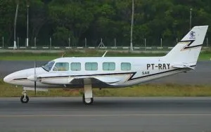
To meet contracted services with the utmost professionalism, as well as expectations for future services, ESTEIO decided to expand its fleet by acquiring another aircraft, a twin-engine plane with registration PT-RAY. This year, ESTEIO acquired 10 more units of the PCM (Pipeline Current Mapper) equipment for locating and detecting possible damaged coatings and ruptures in buried pipelines. GPR became an important tool for locating buried pipes and cables. Avoiding existing buried interferences is a prerequisite for implementing any new development. GPR provides data for evaluating new routes and identifying buried obstacles. Planning before excavation reduces costs and avoids unforeseen issues during construction. To offer clients this additional line of services, in 2003 ESTEIO acquired a new SIR-3000 line GeoRadar device. This equipment allows for the most diverse subsurface investigations, whether of buried elements or soil stratigraphy.
Year 2002 – Pipeline Current Mapper
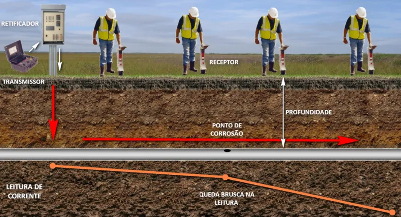
In 2002, aiming to further improve subsurface investigation methodology, ESTEIO acquired the PCM (Pipeline Current Mapper) buried pipeline mapping system from Radiodetection Inc.
This system enables precise pipeline location through the induction of electrical current in buried pipes and the corresponding measurement of its propagation intensity via a receiving antenna on the surface.
In addition to locating pipelines, this equipment can detect coating failures by analyzing the detected current leakage.
In that same year, ESTEIO began operating in Highway User Service Programs through Highway Inspection teams and Highway Operation Support teams on the road network of the Basic Service Units (UBAs) of the State of São Paulo. These services continue to be provided to this day.
Year 2001 – Airborne Laser Terrain Mapper
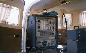
In 2001, ESTEIO introduced LIDAR (Light Detection and Ranging) technology to Brazil with the acquisition of the ALTM (Airborne LASER Terrain Mapper) equipment from the Canadian company Optech Inc.
This equipment acquired digital terrain elevation data through LASER scanning, with a precision equivalent to GPS, but with much greater density and speed.
Year 2000 – GPR Technology

In 2000, ESTEIO acquired GPR (Ground Penetrating Radar) equipment. GPR allows for non-invasive subsurface investigation through the continuous emission of electromagnetic waves into the ground.
After many years of development, GPR is currently considered the most sophisticated equipment for shallow-depth surveys and investigations.
GPR became an important tool for locating buried pipes and cables. Avoiding existing buried interferences is a prerequisite for implementing any new development. GPR provides data for evaluating new routes and identifying buried obstacles. Planning before excavation reduces costs and avoids unforeseen issues during construction.
Year 1999 – VEXCEL ULTRA SCAN 5000
In 1999, ESTEIO acquired the MrSID image compression system from Lizardtech Inc., to enable the delivery of raster products in a compact and reliable manner. This image compression system allowed for the management of larger image files with virtually imperceptible quality loss due to size-reduction mechanisms. This made the production of colored, higher-resolution image files, such as digital orthophotos and digital mosaics, faster and more efficient.
In 1999, ESTEIO also intensified its use of the ERMapper program to achieve better performance in mosaicking and digital processing of both photogrammetric and satellite images.
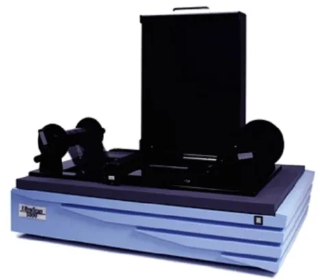
During this period, ESTEIO acquired another photogrammetric-quality aerial film scanner, the VEXCEL ULTRA SCAN 5000, from Vexcel Imaging (Austria), to increase its photogrammetric capture capacity and the production of digital orthophotos.
Year 1998 – Digital Photogrammetry

During 1998, ESTEIO made a significant investment in the field of Digital Photogrammetry. During this period, it acquired three DPW 770 NT Digital Photogrammetric Workstations from LH Systems to increase its productivity in stereophotogrammetric restitution.
The workstations had modern stereophotogrammetric restitution, digital aerotriangulation and digital orthophoto production programs.
In addition, it acquired a new ABC-PC analytical photogrammetric workstation from InterMap Analytic for use in model reading activities for aerotriangulation and stereophotogrammetric restitution.
These pieces of equipment joined the equipment already existing at the company and doubled its production capacity in stereophotogrammetric restitution and aerotriangulation.
Year 1997 – Analog Camera

In 1997, ESTEIO acquired the ZEISS RMK-TOP aerial camera, manufactured by Carl ZEISS Ag, which improved the quality of black-and-white and color aerial photo shoots, as this semi-automated camera features several exposure control, drift and tilt resources, and an interface with a GPS receiver for determining the coordinates of the perspective centers at the moment of each shot.
Year 1996 – Bathymetry with GPS
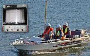
In 1996, ESTEIO acquired a set of equipment for carrying out bathymetric surveys, consisting of a Leica SR-530 GPS satellite receiver and an ODOM SDH 13A digital echosounder, both connected to and managed by specific bathymetry software called Hypack, which enables the correlation between depths obtained by the echosounder and planimetric coordinates from GPS/RTK (Real Time Kinematic) along the navigated lines.
Year 1994 – Digital Orthophoto and Image Processing

In 1994, ESTEIO acquired a digital orthophoto and image processing system, which includes a LEICA DSW 100 scanning station, the LEICA DPW 770 image processing station, and the ERMapper 5.0 system for digital image processing. This configuration was chosen based on several experiences with suppliers from Germany, Switzerland, Canada and the United States.
Year 1993 – GPS and Aerial Photogrammetric Coverage
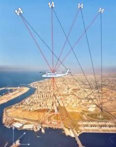
In 1993, GPS (Global Positioning Systems) and aerial photogrammetric coverage came together.
With the acquisition of GPS equipment for navigation and the preparation of the aerial camera and geodetic GPS receiver aboard the aircraft, it became possible to obtain the spatial coordinates of the perspective centers of aerial photographs at the moment of each image capture.
These coordinates were used in Aerotriangulation processing, allowing for greater rigidity in image blocks and a significant reduction in the number of ground control points required.
Starting in 1993, adapting to the new needs of existing road systems, ESTEIO began operating in Highway Operations. ESTEIO provided specialized services for Weight Enforcement on highways through the operation of dynamic, static and portable electronic scales, maintenance and upkeep of Vehicle Weighing Stations in Santa Catarina, continuing to this day to provide vehicle weighing services on highways in various States, both at the federal and state level.
Year 1991 – Development of a CAD System

In 1991, ESTEIO developed a CAD system (TEMap, registered with SEI under No. 21,364-0) to meet the company's internal needs in the areas of digital stereophotogrammetric capture, digitization, digital cartography editing and as a basic tool for geographic information systems, featuring the following resources: digitization, photogrammetric data capture, editing, project management, creation of symbols and traces, generation of special entities (parallels, curve interpolation, etc.), database connection, file conversion, among others.
Year 1990 – Pioneer in Geodetic Operations with GPS

In 1990, in a constant effort to keep up with technological evolution and working methods, ESTEIO was a pioneer among Brazilian aerial survey companies in equipping itself with NAVSTAR-GPS satellite trackers to carry out geodetic operations, achieving excellent results in the services performed both in terms of precision and productivity.
Year 1988 – Geoprocessing and Digital Image Processing
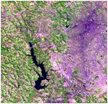
In 1988, also following international trends, ESTEIO acquired the SITIM/SGI image processing system from Engespaço (Brazil), absorbing geoprocessing and digital image processing technology using orbital images (LANDSAT, SPOT and SOYUZ), with which it carried out various geoprocessing and satellite image processing projects, such as providing technical thematic mapping services using satellite images to study the route of the Bolivia/Brazil gas pipeline (PETROBRAS).
Year 1986 – Zeiss Orthocomp Z2 Analytical Orthoprojector
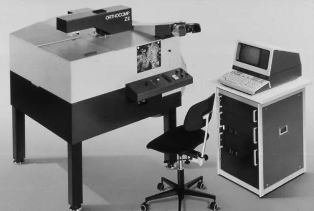
In 1986, the computerization of photogrammetric processes was enhanced with the acquisition of a Zeiss Orthocomp Z2 analytical orthoprojector, manufactured by Carl ZEISS Ag (Germany), along with an additional HP 1000 computing unit, used for the production of orthophoto maps in a semi-automated process, in which photogrammetrist intervention was reduced to what was strictly necessary in generating digital orthophotos.
Year 1985 – Digital Cartography

In 1985, with the acquisition of a Zeiss Planicomp C-120 analytical station, coupled with an HP 1000 minicomputer and PLANIMAP restitution system, developed by Carl ZEISS Ag (Germany), together with the automation of analog equipment for use with this system, ESTEIO became the first Brazilian company qualified to carry out digital cartography services.
Year 1981 – First Microcomputers

In 1981, ESTEIO acquired its first microcomputers (PCs) and programmable digitizing tables for use in engineering calculations.
With these resources, ESTEIO developed automated methods for rural cadastre products (area calculation, descriptive reports and the generation of individual plot plans within land tracts) and the corresponding issuance of agrarian titles for various clients.
Year 1980 – Mapping by Orthophoto Maps
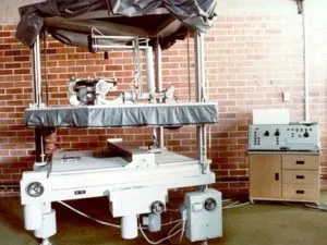
In 1980, with the acquisition of the GigaZeiss GZ-1 instrument from the German company Carl ZEISS Ag, ESTEIO also began performing orthophoto mapping services using the mechanical-photographic method.
With the incorporation of this equipment into its production line, ESTEIO became one of the first Brazilian companies to be able to provide orthophotographic products.
Year 1978 – Planimat D2
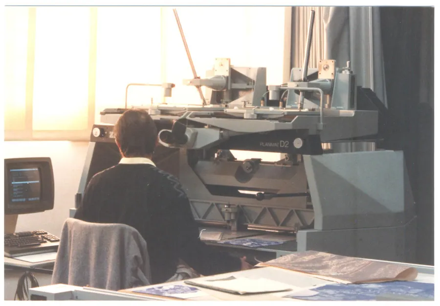
The Planimat D2, manufactured in the 1970s by Zeiss, was one of the most advanced opto-mechanical stereocomparators of its time, featuring high-quality optical systems, motorized film transport mechanisms, and other technological innovations for that period. The Planimat D2, coupled with an EZ 2 drawing table, made it possible to determine three-dimensional terrain models with submillimetric precision. For ESTEIO, the Planimat D2 was essential equipment in the routine photogrammetric processing of analog aerial images. As such, the investment in the Planimat D2 represented not only a technological advance, but also a competitive differentiator for companies seeking to build their reputation in providing mapping services during the analog era.
Year 1977 – Revolution in Rural Cadastral Surveys

In 1977, working in the field of ground surveys, ESTEIO revolutionized the rural cadastral survey methodology with the introduction of pre-marking property boundaries for identification and measurement through the photogrammetric process after aerial coverage of the plots at the so-called Pepery Property, in the State of Santa Catarina, a service contracted by INCRA – the National Institute for Colonization and Agrarian Reform.
Year 1976 – Category "A" at EMFA
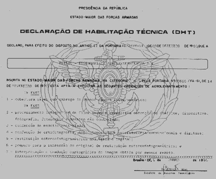
The growing need to use aerial photogrammetric surveys as a support base for project development led ESTEIO to equip itself and prepare a technical team to carry out aerial survey services. Thus, in 1976, it was registered as a category "A" company with EMFA – the Brazilian Armed Forces General Staff – and began carrying out aerial photogrammetric coverage and conventional photogrammetric mapping.
Year 1969 – Founding
Founded in 1969, ESTEIO Engenharia e Aerolevantamentos S.A. is a privately held Brazilian company. Operating as a consulting firm, in the early days of its existence its activities focused on the execution of projects and supervision of civil engineering works such as highways, railways, airports, sanitation and power transmission lines.
Since its founding, ESTEIO has been dedicated to consulting in the transportation sector, where it has already executed thousands of kilometers of projects, monitoring, supervision and inspection of works, including earthmoving, paving, drainage, current engineering structures, slope stabilization, retaining structures, bridges and viaducts, geotechnics, hydrology, geology, functional planning, traffic studies, budgeting, restoration and duplication projects, technical-economic feasibility studies, and environmental impact reports (RIMA) for highways and railways.