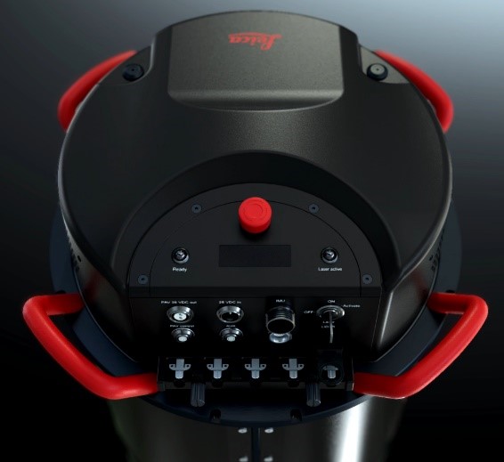
 With the easing of the new Coronavirus pandemic, the geotechnology market has been showing clear signs of warming. To keep up with this growing demand, ESTEIO, once again, bets on productivity gains with new technologies and invests in a new aerial sensor – now in the Leica CityMapper hybrid sensor.
Understand the reasons, the technology, and the impacts on ESTEIO’s products and services with the use of this new equipment.
The following text was written in the structure of questions and answers, in order to make it easier for you to read and learn more about the new technologies of this sensor. If you have any further questions, please just contact us.
What does a “Hybrid Sensor” mean?
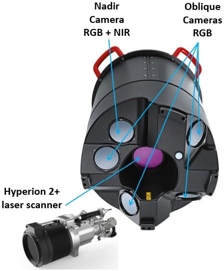
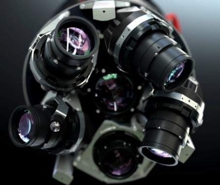
The name “hybrid sensor” is given to sensors that bring together in the same equipment two or more technologies that were previously distinct. Our Leica CityMapper hybrid sensor brings together a 2,000akHz Hyperion2+ laser scanner and five medium format cameras, one at nadir collecting simultaneously in the RGB and Near InfraRed (NIR) bands, and 4 oblique cameras, collecting in the RGB bands.
Why did ESTEIO decided to invest in a hybrid sensor?
All decisions for the company’s major investments have always been made by a combination of factors such as boldness, necessity, opportunity and strategy. In 2020, ESTEIO made a major investment in the Leica ADS100 large format sensor. At the time, we were already considering and also studying the possibility of investing in a new LiDAR sensor. With the increasing demand for several services, and particularly covering cities for oblique imaging, 3D modeling and a higher density of laser points, it has become necessary not only to master the technology but also to have equipment developed specifically for this purpose with great reliability, precision and productivity. In 2016, ESTEIO pioneered performing the first photogrammetric oblique flights in the country with a non-hybrid Leica RCD Penta sensor, which has preceded the CityMapper. In these six years since then, the technology was consolidated and both oblique imaging and the three-dimensional urban model have been adopted by several cities around the world.
ESTEIO already has Laser technology, so why purchase a new sensor?
ESTEIO had three LiDAR sensors, one Optech with 25 kHz, currently out of use, and two Leica ALS50-II sensors with an operating frequency of 157 kHz. What we are now acquiring is the new Leica hybrid sensor that contains the Hyperion2+ 2,000 kHz laser scanner – capable of emitting and measuring two million LiDAR pulses, or points, in a time span of one second – that is, this new sensor it is nominally thirteen times more productive than our last sensor and eighty times faster than the first equipment purchased in 2001. We are seeking to increase the quality and productivity of our services and, if possible, to lower our prices, thus increasing our competitiveness. The laser sensors currently in operation in the country, with rare exceptions, do not have an operating frequency above 500 kHz.
Why do you say “if possible”, to lower the prices?
Because that is not always what the market demands. We have noticed that it has been common for contractors to demand more technology, quality or technological improvements and not only a cost reduction. That is, they seek as much work as possible with a previously defined amount. The cities of Curitiba and Porto Alegre are good examples of this. They recently contracted airborne survey services through the Technique and Price modality, thus providing higher scores to the bidders that offered some advantage. Thus, the lowest price is always desired, however, the advantage, such as a higher density of points in the LiDAR survey, a higher image resolution, oblique imaging, a three-dimensional model, among others, are the improvements or products that are very welcome upon contracting. However, if the objective is only a cost reduction for a product without an any great technological advantage such as, for example, only the same density of laser points in the terrain, our new sensor will fully meet this demand with a lower price and faster execution.
Is the Leica CityMapper hybrid sensor to be used in cities only?
 Yes, and no! Thinking about using its full potential – LiDAR, nadir and oblique images simultaneously, it is an exceptional tool for urban mapping. However, laser and nadir imaging are also great tools of our CityMapper H2 sensor for use in corridors, forestry, mining, as well as for mapping large areas, since it has a maximum operating height of 5,500 meters. It`s also possible to adjust the laser aperture angle and eventually change the focal length of the nadir camera, allowing for different alternatives of the field of view – which characterizes the great versatility of use of this sensor.
What is the configuration of this sensor?
ESTEIO’s new Leica CityMapper H2 sensor has the following configuration: 2,000 kHz Hyperion2+ multi-pulse laser scanner with registration of up to 15 returns; nadir camera with 83 mm focal length in RGB and NIR bands and 4 oblique 156 mm focal cameras in RGB bands with 45-degree viewing angle. All image sensors have lenses developed specifically for photogrammetry and have mechanical forward motion compensation devices – FMC, which eliminates blurring due to forward motion and allows for the acquisition of very high-quality images even in low light conditions; high performance gyro-stabilized mount and high precision inertial system, among other new technologies. In addition, the LiDAR unit also allows for a conical scan. Moreover: all of the above work simultaneously. One four channel RGBN nadir image is obtained in a single shot, four oblique RGB images and a high-point-density laser scanner, as shown in the sensor’s footprint.
How important is it to use all these sensors simultaneously?
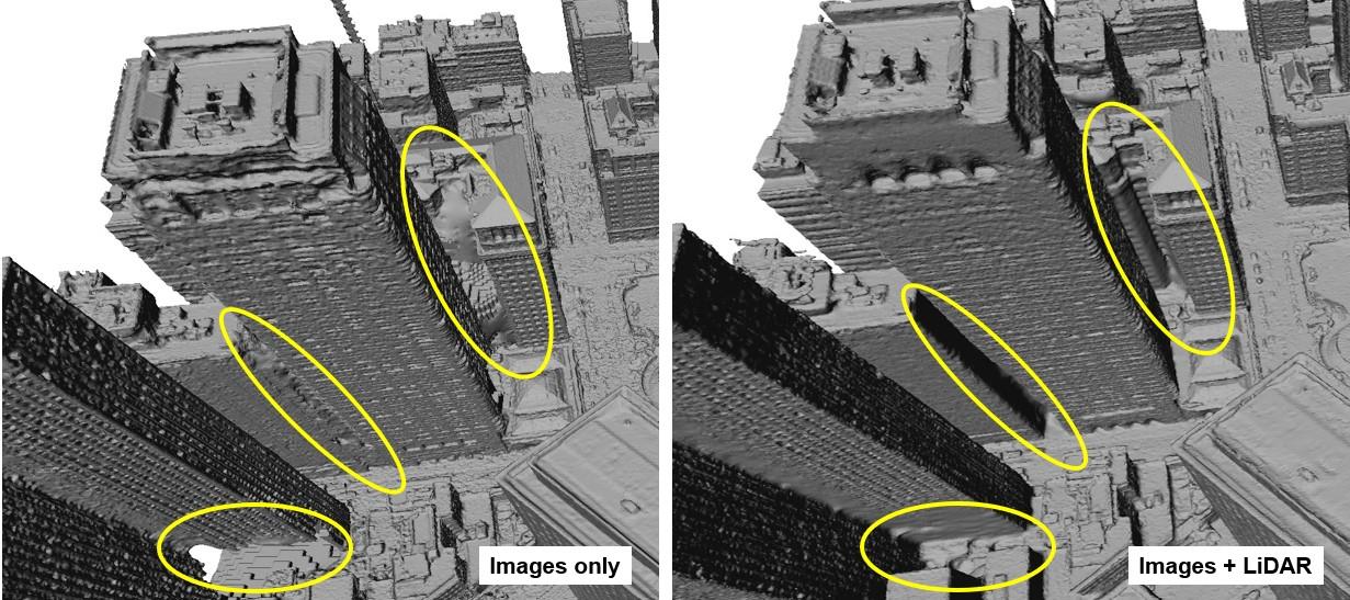
In the generation of 3D City Model, the fusion of the hybrid sensor technologies – images and laser data – allows, for example, for an improved definition of large buildings in verticalized regions, as shown in the figure below. The simultaneous surveying brings, as main benefits: lower cost and time for aerial operations, since it is done with a single flight that would sometimes take two or more. Additionally, the simultaneous acquisition brings some specific benefits such as, for example, the possibility that all image features are strictly the same as in the laser survey, and vice versa, something that is also very important in forest mapping. In any areas where occlusions prevent stereo imaging, those surfaces can be measured from LiDAR vantage point, filling in areas that are not fully seen in urban infrastructure. And still, the future usage of hybrid georeferencing between images and LiDAR data, with significant gains in the final accuracy and consistency result of the products.
What is the best GSD imaging and laser survey density possible with CityMapper?
Our CityMapper H2 operates at flight heights from 300 to 5,500 meters, which results in a wide range of options. The imaging GSD, which is the terrain pixel size, is a direct function of the flight height and the focal length used. The LiDAR point density depends on the flight height, aircraft speed, scanning angle and the laser pulse frequency used. Under normal and usual conditions, it is possible to fly at 1,000 m of height and at 222 km/h of speed (120 knots). Under these conditions, with nadir focal length of 83 mm, a GSD of 6 cm and a density of 29 points/m² is obtained, for swath of 620 m. With that same 83 mm focal length, a GSD of 2 cm at 300 m height of flight and a GSD of 34 cm with a height of 5,500 m would be obtained, with a high density of LiDAR points on the terrain, varying with flying height.
What new products will be offered with this new sensor?
The 2 MHz Hyperion2+ Laser scanner is the state-of-the-art in LiDAR today, it has conical scan mode, ungated multi-pulse responding to up to 35 simultaneous MPiA zones, and recording capacity of up to 15 returns, waveform recording, etc. We can now offer LiDAR surveys with much greater usage potential than before, in corridor and large area mapping, forestry, mining, urban applications, and many others. With the imaging collected from the five cameras, our customers will have the possibility of products such as Oblique Imaging, 3D City Model, Orthophotos, True Orthophotos and Photogrammetric Stereo Plotting, all of which are essential products for smart cities or even for the new concept of digital twins.
What does the Conical Scan deliver in terms of improvement in a laser survey?
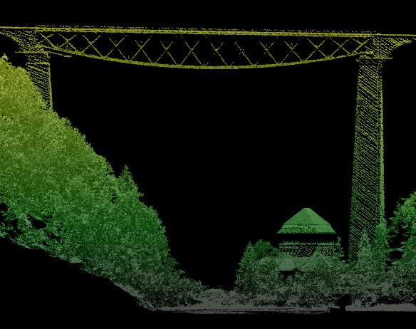
Until recently, LiDAR airborne sensors only collected points with a sawtooth or sinusoidal distribution where the scanning action was in a single vertical plan; 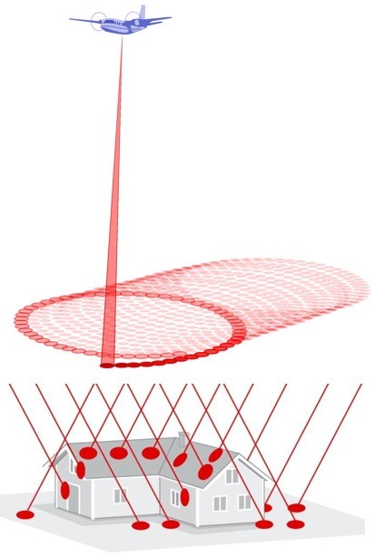 because of this, the density of points on the terrain was smaller in the center and larger at the edges of the swath. Conical scan was recently introduced and the Hyperion2+ LiDAR scanner of the Leica CityMapper sensor also allows this option. Normally, though the conical, or oblique, scan pattern is selected in combination with a constant-density mode, obtaining points with regular distribution and density on the terrain, regardless of position within the swath. In addition, the conical scan allows each region on the terrain to be measured from two different vantage points along the flight line and, in the case of lateral overlap of 50%, each region of the terrain would be measured from 4 different vantage points. This allows, for example, a greater chance of penetration of the laser pulse in forested regions. Another aspect to be considered is that the conical scan, because all the sights are oblique and with the same angle, adjustable between 20 and 40 degrees, allows a high and homogeneous precision, as well as a better definition of vertical elements such as trees, bridges, lampposts, towers, and buildings walls, which are essential in the construction of high accurate three-dimensional urban models.
What does the ability to measure fifteen returns improve in a laser survey?
 The more measured points there are, the better the LiDAR survey will be. The vast majority of sensors from previous generations only allowed the determination of four returns of the laser pulse, that is, the first, two intermediates and the last return. Now, it is possible to measure up to thirteen intermediate laser pulse returns, and this brings a great advantage for use in mapping complex areas, such as forests and cities, by allowing a much better mapping of everything that lies between the Digital Surface Model and Terrain – DSM and DTM.
What does the Waveform improve in a laser survey?
Waveform analysis technology was introduced a few years ago in LiDAR equipment and, in addition, our CityMapper H2 sensor features real-time waveform analysis, which performs real-time waveform-to-range and intensity calculations based on a high-speed digitizer, to more accurately determine the time and the intensity of the laser pulse return, thereby allowing a faster processing with a significant reduction of the data volume as compared to full waveform recording and post-flight analysis. There is less information to be recorded, transferred and processed when compared to its competitors or even its predecessors. This makes applications that require multiple returns more assertive, accurate and more suitable, as in the case of mapping forest, urban and regions with high relief variation. This real-time technology, in effect, provides the benefits of full waveform recording, without the bulk of data or long processing time that were needed in the past.
What other technological features does this new sensor have?
Our previous LiDAR equipment, the Leica ALS50-II was acquired in 2008, therefore it is almost fifteen years of evolution that this new sensor brings. An important technology that the CityMapper H2 has is the state-of-the-art gateless MPiA – Multi Pulse in Air. This technology allows up to thirty-five laser signals to be emitted before the first is returned to the sensor, thereby allowing extremely high operating pulse rates, even at high flight heights. The equipment has a very wide operating height range, from 300 to 5,500m, allowing its use in the most diverse applications, whether urban or rural, always with high density of points and precision, in addition to countless other improvements over these fifteen years of technological evolution in hardware and software solution, which is covered by the HxMap software in its several modules, such as: Ingest (raw data processing), APM, Triangulation, Ortho Generator, Info Cloud, Core LiDAR, etc. This is a complete, efficient and optimized solution for integrated image and laser data processing, with all steps using the same trajectory data. Several new technologies were also incorporated into the software, such as SGM – Semi Global Matching, which allows dense, efficient, accurate and fast generation of digital surface models from imagery, which are important in the construction of the 3D City Model and Digital Twins.
So far, we’ve only talked about hardware, how about the software?
Unlike our previous investment in the large format sensor, the investment in software has now been much more significant. RealCity is the name of the complete hardware and
How many oblique sensors are in operation in the world today?
The numbers vary greatly with time and also with the source consulted. But it is likely that there are about 80 oblique systems producing nadir and oblique images for orthophotos, true orthophotos and 3D models, however, there is a much smaller number of hybrid systems in the market. ESTEIO is the first Brazilian company to have a hybrid sensor and is very proud of this, and could not fail to offer this technology to its customers. When considering proprietary, non-commercial and non-photogrammetric systems, one could reach a number close to 100 oblique sensors in operation worldwide. The 3D Urban model is an essential tool in the construction of digital twins and is already being used by smart cities such as Amsterdam, Duisburg, Linz, London, Munich, New York, Paris, San Diego, Tokyo, Utrecht and Vienna, among many others.
In 2016, when ESTEIO produced the 3D model of the Olympic Park in Rio de Janeiro, it was mentioned that the technology might take some time to be absorbed in Brazil. What has changed in that short period of time?
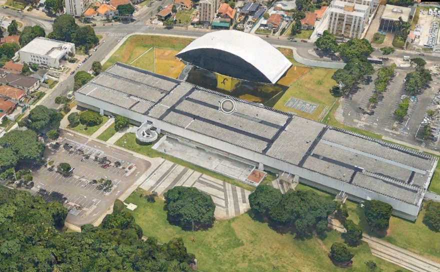 After more than six years, the city of Curitiba is fully using the three-dimensional urban model (image), the city of Campo Grande is performing it and several other cities are interested in 3D City Models and even in digital twins. The oblique imaging alone has the greatest potential in Brazil. It is an exceptional tool for urban cadaster, because it allows the detailed visualization of all the buildings inside the lots and blocks, – all sides are imaged, while the usual land mobile mapping provides images at high resolution, but only of the front side, as it only presents the street view. The smaller municipalities can choose, for example, to hire the oblique imaging of the entire urban area and, if there is an interest in modeling, they can choose to only perform the 3D city model of the central area and, thus, be able to explore the full potential of the oblique imaging in cadaster and 3D city model, only in the region of greatest interest, without requiring a large computational structure nor greater investments.
Can this sensor be operated by Drones?
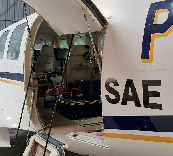 It’s not impossible, but it would take a large drone, and that is not the case. The sensor and its peripherals weigh about 130 kilograms, consuming an average of 850 Watts, with a voltage of 28 VDC and a current of 50 A – that is equivalent to the current of a one hundred and fifty square meter residence. With these requirements, it would cost much more than a manned aircraft for a drone to safely transport and operate uninterruptedly this sensor for a few hours. The CityMapper is the only hybrid sensor produced and marketed to date, and obviously it is not designed for drone operation. Hybrid sensors such as the Leica CityMapper would need to be miniaturized and simplified in order to be operated by conventional drones, and there would still be the remaining issues of the great limitation of flight autonomy and the low operating height of the drones. If such reductions in size and weight were possible, there would certainly be significant losses in productivity and also in the quality of the products obtained, for the moment at least. There are already drones operating simultaneously different sensors for image and laser data collection, but not with a hybrid sensor neither with five cameras. ESTEIO will operate the CityMapper H2 in one of its aircraft, the twin-engine Piper Navajo, capable of transporting nine people and with a flight time of 6 hours.
What makes ESTEIO believe that Brazilian cities will adopt this technology?
There are countless cities around the globe that are already using and even remaking the 3D city model. Every city that intends to become a smart city, or even that already is, should use this tool. There is even an entire country that has already had its territory covered with oblique images and built the 3D model – the Netherlands, with a land surface of more than forty thousand square kilometers. Among others, European, Japanese and Korean cities are the ones that have most employed this technology to generate their digital twins. It seems to us that it is only a matter of time before Brazilian cities mass adopt the technology.
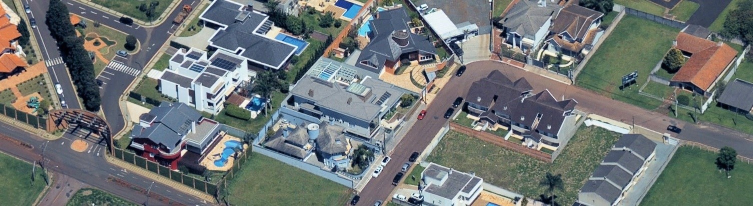 One of the first Oblique images collected by ESTEIO’s CityMapper – GSD 12cm
Valther Xavier Aguiar is a cartographic engineer, Chief Technical Officer of ESTEIO Engenharia e Aerolevantamentos S.A. and
president of ANEA – Associação Nacional de Empresas de Aerolevantamento.
This text has received contributions and illustrations from Klaus Neumann, Willian Kim, and most notably Ron Roth of Hexagon/Leica Germany, Chile, and USA.
valther@esteio.com.br, www.esteio.com.br. November/22