
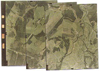
Aerial Photographs are widely used for Cartography and can have several types of emulsion:
-
Black-and-white panchromatic: this is the most widely used emulsion for mapping and photo interpretation;
-
Color: indicated for interpretation due to its ability to differentiate colors and tones;
-
Black-and-white infrared: due to sensitivity to longer wavelengths, it images more completely through haze and fog than panchromatic emulsion. Used for special cases of photo interpretation, such as oil spills;
-
Color infrared: also known as false color. Used for photo interpretation, particularly in detecting diseases in crop and forest areas, soil analysis and water pollution.
Development and Printing
After completing the Aerial Coverage, the next steps are Development and Printing.
With Development, the film is converted into a negative, from which positive copies can be obtained. Positive copies can be made on opaque photographic paper (conventional photograph) or on transparent material (diapositive or diafilm).
The transfer of the image contained in the negative to the positive is done through a process of exposing the paper to a certain amount of light that passes through the negative.
Contact Printers produce copies with the same dimensions and scale as the negative and have wide application in Photogrammetry.
Projectors or Enlargers, on the other hand, allow for the production of copies with scale variation. A practical example is enlargement.
Verification
After the film is developed, copies are made to check the quality of the flight.
The presence of Drift is verified — the angle between the axis of the flight strip and the axis of the photo; deviations between actual and planned flight lines; failures in lateral and forward overlap; image sharpness, contrast and photo numbering.
Products
According to the Technical Specification of each Service, Final Products are prepared that depend on Photographic Processing, such as: collections of definitive aerial photos, enlargements, photo indexes and mosaics.
A Photo Index is a photographic reduction of the set of photos at an approximate scale, covering a given area, juxtaposed to one another at their overlap zone.
Its purposes are: to know the photographed area and the flight specifications, to have an initial approximation of the region's area, and to serve as a basis for requesting photographic copies and planning ground control.
A Mosaic is a continuous image of the terrain, constructed by juxtaposing individual photographs, with adequate overlap, assembled technically and artistically. It is therefore a set of perspective views of the terrain. The image is assembled to give the impression that the whole set is a single photograph.
The digital Mosaic is obtained by juxtaposing digital photographic images obtained by scanning photos or film and combined by detail. It offers the advantage of on-screen file viewing, in addition to allowing the image to be printed, at various scales, using an appropriate plotter.
Capabilities
ESTEIO is able to carry out:
-
Rectified black-and-white and color photographic enlargements;
-
Development of black-and-white and color film and printing of black-and-white and color aerial photos;
-
Photo indexes, simple, semi-controlled or controlled mosaics;
-
Orthophoto maps via photographic contact printing.