
The constant development of airborne image-capture systems has brought large-format digital sensors to market. Today, ESTEIO highlights the ADS100 sensor, acquired in 2020.
The ADS100 is a large-format digital aerial sensor manufactured by Hexagon Leica Geosystems. It captures continuous imagery in RGB and near-infrared (NIR) bands, with high radiometric resolution and the ability to obtain imagery with up to 3 cm GSD.
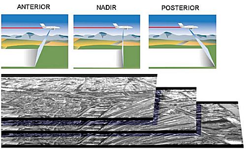
Being a linear sensor, the image is captured as the aircraft scans the terrain, producing an image strip with constant perspective. Acquired by ESTEIO in 2006, this sensor has shown several advantages in the cartographic production process.
Flight Plan
During the flight planning phase, the FPES (Flight Planning and Evaluation Software) program allows for automation of the process of creating flight strips; this program considers all the parameters necessary to guarantee perfect coverage of the area of interest, as well as the precision and quality of the image to be acquired.
The FPES creates a flight planning file that is transmitted to the sensor control unit. In this unit, through the FCMS (Flight & Sensor Control Management System) program, all flight control is carried out.
The FCMS controls the correct positioning of the aircraft during the execution of the strip. If drift or variations in flight altitude are detected, image recording is automatically canceled. The satellite constellation, PDOP and VDOP values are also monitored during the flight to ensure the quality of GPS/IMU data for subsequent image processing.
Image Capture
The simultaneous acquisition of panchromatic and multispectral images (RGB and near infrared) is one of the advantages of this sensor; all images are captured at the same resolution, without the need to colorize panchromatic images. During the flight, up to 10 images can be captured, as shown by the sensor's focal plane.
Image recording is triggered by the flight director, who chooses which images are recorded. The CCDs are arranged asymmetrically on the focal plane, forming angles of 14° between the Forward and Nadir images and 28° between the Nadir and Aft images. Stereoscopic composition can be achieved by combining two views.
As the strip is flown, recording by the CCDs is done continuously, thus creating a single image for the entire length of the strip.
The consequence of this is the existence of stereoscopy across 100% of the area of interest, with the possibility of combining 3 different stereo pairs (Forward and Nadir, Nadir and Aft, Forward and Aft).
As soon as the flight is completed, image processing can already begin. As an advantage, we have the elimination of the laboratory process at this stage; there are no expenses for photographic film and chemical products. The time to transfer the film to the lab and the development time are replaced by simple processing at the flight site itself, and the need for a re-flight is known immediately.
With the acquisition of digital images, the scanning process previously required is eliminated. Consequently, the need to treat images for possible scratches or residue created by this process is also eliminated.
The aerotriangulation process is also streamlined with the use of ADS40 images. Because it is a supported flight, GPS/IMU data processing already allows for good orientation, ensuring that the creation of tie points between images and strips can be carried out automatically, with a large number of points and high correlation precision.
Because the strips are continuous and the flight is supported, the number of ground control points required for a good adjustment is also reduced; points only at the extremes of the blocks already ensure a good adjustment.
Several advantages can be cited in the photogrammetric restitution process and orthophoto generation. The reduction of "models" in the process is one of them, especially when it comes to work along linear features such as pipelines and roads, optimizing the production process.
The geometric quality of the images is one of the most important points. The high definition of the images facilitates the capture process, and radiometric quality facilitates the interpretation process.
Even in high-altitude flights, with a GSD greater than 0.40 m, equivalent to a 1:30,000 flight, radiometric and geometric definition is superior to conventional flights.
The identification of hidden objects, due to shadows or inclinations, is achieved through the combination of the different viewing angles.
The simultaneous capture of color infrared imagery allows for additional data for vegetation studies and other interpretations.
In the orthorectification process, there is a considerable reduction in the need for image treatment; because the strips are continuous, there is no longer mosaic editing along the strip, only connections between strips need to be treated.
Sheet cutting is carried out without the need to edit the image within the same strip.
Because it involves a parallel perspective, the nadir image provides practically vertical images, making the orthophotos almost a "true orthophoto".
Related Articles
-
Weather Conditions Favorable to SAE (Specialized Aerial Service)
-
ESTEIO Begins Process of Replacing Aircraft E.L.T. (Emergency Locator Transmitter) with New Digital System
-
SAE (Specialized Aerial Service) During Days of Air Traffic Blackout
-
Radiometric Quality of ADS100 Sensor Images
-
Advantages of Using ADS-40 Camera Images